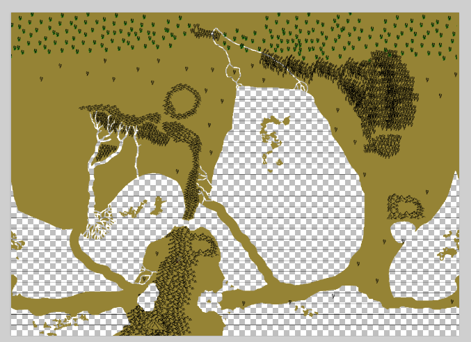
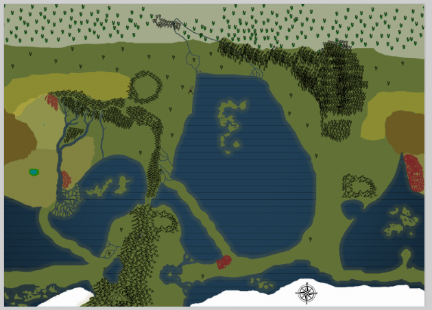
Islands in the oceans. Avoid putting any islands near Cornerstone (which is situated exactly on the equator if I remember correctly). Also, with the Fractal Ocean, I believe that most of it is quite deep, so natural islands will be is areas near the coast, especially where the ocean has eroded from its original shape. Also, it is probably appropriate to put lots of islands in the south pole.
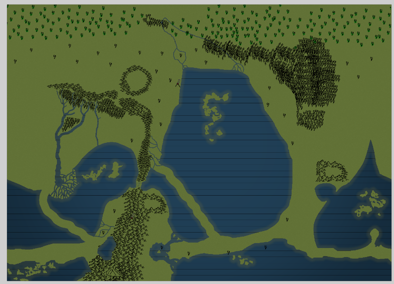
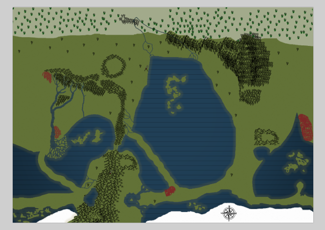
Shuffle the edge of the map over, such that Mesathallassa (which is one of the more important regions now) is not cut in half. Running the border through the Changing Plains should work. This can be achieved by expanding the Canvas size, copying a section of the map over, then condensing the canvas again.
Jvan's peninsula. You seem to be on top of this.
Mangrove should be larger. Again, you seem to have dealt with this, by using an older version of the map.
Venomweald was too big, and Nice Mountains too close to Ironhearts. Again, you fixed that.
Ocean reshape (fixed)
Make the Acalya outbreaks a different colour (something to reflect their nature as crystal trees) (my suggestion)
Rivers and lakes. Also of note: real rivers never branch in the downstream direction. One direction is always preferable to the other. Small islands may be found in the middle of rivers, and at the very end of its flow the river may pan out into a delta, but otherwise rivers don't branch.
Ensure that Alefpria is properly labelled. Same for the Metatic Ocean.
Oath of Stilldeath and Portal to New Chronos belong under Old Bark-Skin
Put an ice cap of some size on the South pole.
Additions/features to put back in:
New volcano, in the coast by the Metatic Ocean north-west Acalya outbreak.
@WrongEndoftheRainbow Not sure whether you still need this, but here's a summary of the debate:
1) Please consider shrinking down many of the geographical features. Things are beginning to get crowded and we are still meant to be working on a huge, Earth-like planet.
1.1)
2) I would also suggest moving the map edges more westward, closer to the changing plains. Mesathelassa is better developed at this point.
3)
4) More Termite:
-What happened to Jvan's peninsula? She's somehow ended up at a channel between the southern ocean and the fractal sea? She's always been at the northernmost point of an isthmus stretching up from land, specifically so that you can reach her on foot or horseback from both east and west; Somehow that got turned completely inside out. -The Mangrove shrunk substantially and the Forgotten Craglands inside it went AWOL. -The Shimmering Sea changed shape, deleting a section of land to the south of it (which promptly got resurrected as a land bridge enclosing an inland sea?) as well as making Vetros almost coastal. -The Venomweald grew quite a bit, so the Valley of Peace is kind of fusing with the Ironhearts- That's not much of a problem by itself, but the connection between the Steppe and the Valley is growing thinner, which makes Angelblood Ridge hard to place since it took place in the foothills. -The north of the Fractal Sea is growing bigger and lumpier over time, as well as marching steadily west. That vaguely phallic top bit should be a long, narrow inlet directly above Jvan, at least at the very top. -Rivers, people! Where did those Mesathalassan rivers go?
Details added- -Volcano squashing the northwest Metatic acalya outbreak. I should've put it more inland, whoops. Also, Acalya forests have containment zones guarded by Jvan's conglomeration of intelligent species. -The Metera Valley civilisation has probably fused with the Rovaick settlement that was closest to Bormahven. -Forgotten Craglands reappeared- A nest of cliffs and highland weirdforests pierced by the Mahd, in which lies the grave of Slough. -Angelblood Ridge somewhere-or-other.
5) Islands are good. Do we have an Iceland or Hawaii yet? More volcanoes! More islands!
6) More Termite:
-Inland seas! Think of the Aral, Dead and Caspian seas. -Lakes! Lakes everywhere! The Great Lakes, Lake Baikal, Lake Victoria, Lake Chad, Lake Malawi... Big lakes are awesome, guys! -Rivers! Rivers can be used as highways, provided they don't have rapids or waterfalls serving as a chokepoint, and are a lifeline for cities. -Volcanic islands, archipelagos, and atolls! The west Pacific is riddled with islands! Think of Polynesia, Micronesia, Indonesia, the Philippines, the Caribbean, Japan, what have you! -Reefs! Where did the Drenched Flowerbed go? It was our resident Great Barrier Reef analogue. -Mudflats? Sure, why not? -Salt pans! Possibly as a result of a failed attempt at making a sea? That said, though, there's not much civilisation-wise you can do with a salt flat other than trade the salt. -Trenches... Actually, we don't need trenches, the whole south-center of the Fractal Sea practically is one. Plenty of space to be deep, dark and spooky. THAT SAID they do tend to pop up around islands and undoubtedly contain Blood Wells... -Cenotes! Vakarlon made a cave system that riddles Galbar and the Submaterium presumably connects to it, so having some giant flooded holes in the ground would be awesome.
7) Someone finally revises "Capital" into "Alefpria"
8) Khommentary:
-For one reason or another, Lake Grasidar seems to have disappeared from the map, along with Old Bark-Skin :\ -To correct Mutton's edit: the Oath of Stilldeath and the Chronos Portal lies, I believe, beneath Old Bark-Skin rather than in the ruins of the Solitary Mount -With regards to size, I think the map should be stretched slightly, if possible. -Piktaraika (previously Julkofyr's thingplace) should be far smaller than that, and the Hilt also
9) I kinda need the Pictaraika to stay as something that can block passage to Mesathalassa, along with the messed up forest on its west(comming soon), it is an important thing for me. Though if needed the thing could go down on that circle.
10) Land bridges were intentionally made by Vestec when he created the World Mountain in a cataclysmic manner, to contain all the flooding and stuff. At some time we need something to break that. ... Ocean size-changes weren't entirely an artefact of map-creation. Although I'm sure some adjustments might be in order. Especially for Jvan's isthmus; that should be preserved.
11) Rivers are the lifeblood of civilisation. They are important.
12) Agreed. More inland bodies of water. Many of these would probably form naturally. We shall try to remember such features when describing new areas.
13) Volcanic islands are slightly more tricky. On Galbar, currently the only (established) volcanic region is the Ironheart Ranges, which is decidedly inland. Such regions might require a god to create them. In the remains of the south pole, however, are plenty of new islands and archipelagos, although they're more arctic than pacific in climate. The Fractal Sea is unlikely to contain natural islands, due to its unusual depth and formation. The Shimmering Sea, however, could easily have many islands. And the Metatic Ocean, formed by cataclysmic flooding, may have islands where there used to be mountains.
14) There are too many sources mentioning it [Piktaraika] to be round, hell, my Pictaraika shrines are supposedly in a perfect circle. I will be doing something with the surface so I need it to be the least the size of an European country. ...a smaller Pictaraika just means a larger twisted forest. As it needs to be a barrier.
15) I'm really pro-making the map more detailed so it can contain more things, places like the Mesathalassa and the Firewind are the size of small continents in comparison to Earth, surely we could do more with those zones.
16) A Capybara's art:
This is my current personal map of the region, pink is barrier forest to be. Idk how big that means the mountains will be.
17) As in for the question of more islands: earthquakes, volcanic eruptions, tectonic movements, etc. are all controlled by djinn of the respective element. With the Change-Eaters shaking up the delicate balance one can expect a lot more natural disasters and localized events. This seems appropriate because I agree with BBeast that cataclysms of divine making are really strong and shouldn't be happening every few pages, but most of these djinn aren't strong enough to do anything that will have more than a regional impact.
18) I went back and checked the creation post of the Darkened Spires. My apologies. It seems I had the wrong mental picture of it all along. http://www.roleplayerguild.com/posts/3384892 The Darkened Spires were indeed formed from an impact crater, so they would be big and round. Carry on.
18.1) Khommentary:
big and around, yes, but I still think it's currently too big. It's pretty much the same size/almost bigger than the Valley of Peace. But if you require it to be so big for your plans, I guess we can let it slide/assume Illu's alterations affected size also.
19) Regarding map size/things getting crowded. We just need to shrink down many of the sites and their accompanying names, and make it so the map has very high resolution and we can simply zoom in on particular areas to sea details.
20) As for the map border, I believe the suggestion was to change the map border line to run through the Shattered Plains, as that region lacks many features.
21) Really, the map's scale as it is functions fine as an abstract representation of the main things on the planet. It's just that we could use more regional maps to really punch in the scale of Galbar, like Termite suggests and like you did with the Mesathelassan hain tribes. Without that kind of stuff, the valley of peace is still bigger than the Black sea.
22) By the way, I'm all for islands. Feel free to pop them up around the metatic ocean. That was a transmutational clusterfuck that could have resulted in any number of isolated archipelagos. Except near Cornerstone. The water is rather universally deep there.
23) Some enterprising folk could probably dig canals with tollways or some 'reverse ferry' rackets until dynamite is invented. All these new bodies of water formed by the landbridges need names, too. First come, first served! I'm more amenable to the landbridges, not for making bits of the world more connected, but because we as the god characters could make cool moments out of opening them up and they do seem like something sailors would curse Vestec for. It's a bit of a selfish opinion. I'm easy about what happens to them. I'm also all for adding new terrain features. However, not every single one has to be visible from the world map. Regional maps can deal with that kind of stuff.
24)
Areas in red were deleted from the map apparently due to Inkarnate's limited size. I think... we should just return them when given the chance. Mesathalassa also lost a lot of land, but I like the lean strip of the new one (and I already based too much of my time on that size.)
25) I have just one more suggestion for a new map: the flooded south ought to be covered in an ice cap to some extent. I mean, it'll be smaller than it needs to look due to the effect of flattening a sphere (see Antarctica on a flat map), but it still makes more sense than a perpetual thaw on one of the coldest spots on the planet.
Let it be known that the eastern section of the Venomweald is thoroughly under Ommok's grip as part of his ogre kingdom. There might be rogue bands of ogres or small ogre hideouts in other sections of the Venomweald as well, though the ogres mostly keep to wild hills around the jungle and only ever go into the very outskirts. Even they are scared shitless of what is actually inside the jungle, which should tell you something about the futility of putting an actual civilization in there.
Rtron has mentioned plans to add some ogre-like beings called Grotlings to other parts of the Venomweald, so they'll eventually be there to contest control of the area. And from what I recall, I suspect that they'll be even more scary than ogres.
Also, I've already canonized the presence of several Hain villages in that grasslands south of the eastern Venomweald by the river; Ommok encountered them a while back in the post where he went on a long trip across half the world to find his magical stone. Without spoiling much, I have plans for Ommok to return to those Hain villages again.
I'm sure he is a reasonable fellow. I'm positive Keriss can, erm, persuade him into giving up all his land.
<Snipped quote by LokiLeo789>
Hmm. Does the heart of the jungle come rich with resources of any kind other than lumber?
<Snipped quote by Lauder>
There is deadly posion and condensed death.
You will need some mechanic to stop instadeath over there. Loki (and I) have come up with a looong list of countermeasures to make life somewhat viable in that deathtrap, for example.
Yeah its pretty deadly. I mean, Tobias is the son of the most savage dude on Galbar, but he still gonna get his shit kicked in. Plus I get to make up super-predators that don't share my skin tone! (Wink, wink, nidge, nudge)
@WrongEndoftheRainbow. Nice. I like the how you put a different shade of blue around the coasts.
In other news, here is the mega-summary of Page 12. I'll catch up some day.
p12 219 - Vowzra - Three Treeminds are introduced, Morarom Oramomaro, Zinaniza Inazinzani, and Salisilas Lasisal. They find their village empty, and are spirited away to Chronos. Meanwhile in Chronos, a child opens a tomb and is possessed by a purple spirit. The child goes to Galbar. - No Might spent 220 - Ilunabar - Chroma is raised in the dream-land of Iridia, and realises she's a superhero. Makeda is trained by Ilunabar in dream simulations. - Ilunabar: -6 Might to Level up to 5. 221 - NPC Flux - Flux is a water elemental, controlling tides in a lagoon in the Fractal Sea. Old Fishbones, the First Sculptor, encounters Flux, and gives him a gift. Flux reluctantly becomes an oily Sculptor. Flux kills his rival Pyre. Flux later joins Tira and Dancer before they fight Grot. - No Might spent 222 - Amartia, Vestec - Amartia is born when Vestec puts a human into one of the soul-tombs in the Deadwood Sepulchre, with some contribution from Vestec's Chaos. Amartia is shown the world, then thrown into the desert. - No Might spent (?) 223 - Belruarc, 'The Boy' - Belruarc accidentally creates a Holy Site from the open cocoon under Old Barkskin. Belruarc finds a young boy and takes care of him. The boy is revealed to be able to absorb souls. The boy pursues Belruarc, who flees all the way to the Deepwood. Cornered, Belruarc is saved when a boulder is revealed to be a giant turtle, an Avatar of Vowzra. Belruarc and the Avatar depart together. - Belruarc: -30 Might to create a Holy Site. 224 - Grot, Falas, Lifprasil, Belvast - Grot's horde with rovaick, humans, the Order of Lakshmi, urtelem and heraktati, plus Bez the troll, clash with Falas, the four Archangels, an angelic army with Holy Wisps, urtelem, Dancer aka Fencer, Tira, faeries and Flux in the foothills of the Nice Mountains. Many urtelem are killed. Fencer is killed. Meanwhile, Niciel and Vestec talk about the horde and Toun. Bez is made a Hero with discord powers by Vestec. Lifprasil on Ovaedia arrives, talks tactics with Falas, then fights Grot. Tira fights Bez. Bez is beaten, and Tira is heavily wounded. The Lifprasilian army led by Lakshmi arrive. Lifprasil and Falas fight Grot from the inside. Belvast teleports Grot into the ocean. Grot is killed. Vestec saves Bez, and takes some of the Horde and some remains of Grot. The remains of the horde pledge loyalty to Lifprasil. Lifprasilians start going home. - Vestec: -1 Might to make a Hero (Bez) 225 - Teknall - Teknall adds life support and cooling to his Workshop. - No Might spent 226 - NPC Jakin - Set in quiet region of purple sand between Ironhearts and White Ocean, a multiracial area. Jakin, a story-telling human elder, is introduced. Story of nomads, trade, food and agriculture is told. A stone calendar had been built here. - No Might spent 227 - Ventus, Basheer, Murmur - Basheer kills hain undergoing their 'second hatching'. Murmur and Basheer meet. They want to kill Jvanic beings. They meet Ventus, and are adopted into the Zephyrean Skywatch, a Holy Order organised by Ventus, and made into Heroes. - Ventus: -10 Khookies to make a Holy Order (Zephyrean Skywatch), -10 Khookies to empower both Basheer and Murmur into Heroes. 228 - NPC Eskandars - Eskandar decides that his children need lifemates. Three warrior groups are made. Bato, Palo and Orif are promoted to the status of Warrior-Chiefs, the leaders of these groups. - No Might spent 229 - Teknall, Ilunabar, Kinesis, Conata - Teknall plants trees in the Celestial Citadel. Teknall wants a helper to fulfill his promise to the Rovaick, and eventually he, Ilunabar and Meimu settle on two designs. They go to Teknall's Workshop. Kinesis is made/born first, with some mishaps, and is taken by Ilunabar to the Celestial Citadel. Conata is made/born second in a more controlled manner, then taken by Teknall to the Celestial Citadel. - Teknall: -1 Freepoint to make trees, -2 Might to make his two daughters. 230 - Jvan - Diaphane's child enters Galbar's ring and heads to Ovaedis. Nocti, Gaia and Imago are created to inhabit Lex's remains. Jvan invites Astarte to visit Lex. Jvan sends a messenger to follow Slough, and attracts mortal pilgrims. - Jvan: -1 Might to create Nocti, -1 Might to create Gaia, -1 Might to create Imago, -1 Freepoint to attract pilgrims to Slough. 231 - Amartia - Amartia explores the desert and Venomweald, then heads to the Purple Sands. Amartia helps a greedy Troll attain his dreams and become very wealthy. Discord is sown in the Rovaick community, and Amartia becomes a problem solver. Cult of Amartia (aka the Illumi) is formed, followed by humans, hain and trolls, with some influence on other Rovaick. - Amartia: -3 Might to Level up to 2, -1 Might to create the Cult of Amartia 232 - Ilunabar, Lifprasil, Allure - (events mostly take place before the Gort battle) The capital city of Lifprasil's empire is built, construction led by the Divas. Marionettes form the core workforce. First, a wooden port with farmlands is made, to interact with other mortal cities. Second, a grand city, with Allure doing the landscaping, is made, hidden behind fog and illusions, inhabited by the Lifprasillians. Allure invents the glaive. Marionette mounts are made. Lakshmi and Susa are also in the city. Ilunabar builds a stunning palace. Tira is settled into the palace to recover. - Ilunabar: -1 Might to create the palace, -3 Might to adopt a Portfolio (Aesthetic) 233 - Amartia - The Cult of Amartia spreads publicly among hain and humans and secretly among the Rovaick. Amartia converts 7 mortals to be consumed by a specific Sin, a council called the Illumi; Troll of Greed, Azibo of Pride, Tedar of Heresy, Hain of Temptation, Human of Wrath, Human of Gluttony. The nation of Amestris is formed. Trade pressure is put on surrounding Rovaick tribes to assimilate. Xerxes the capital city is built. - No Might spent 234 - Zephyrion - Zephyrion makes a storm of cataclysmic proportions to gain the attention of humans. Many die, prayers to djinn and Elysium go unanswered. One man named Caesus braves the weather to find the cause, and Zephyrion leads Caesus to himself. Caesus is reborn as a Hero, with the Heroship descending through his bloodline, and is renamed to Primus. Zephyrion ressurrects those killed in the storm. Many follow Primus in a mass exodus to the Mahd River Valley, setting up a kingdom. - Zephyrion: -3 Might to make Caesus/Primus a Hero and bless his entire bloodline, -1 Might to fix some of the Storm's damage 235 - Heartworm - Heartworm is in the Caliginous Mangrove. Heartworm consumes some fabric of reality to increase concealment. Heartworm modifies local fauna to be hidden in various ways. Heartworm surrounds itself with Sculptor aides. Heartworm begins exploring Mammon's Black Labyrinth. - Jvan: -1 Might to increase Heartworm's Concealment level by 1, -1 Freepoint to make new living things in the Mangrove 236 - Gerrik Far-Teacher, Kyre - The village being fortified by Gerrik to stop the Horde has finished its walls. Kyre introduces himself as a hain named Wind-Striker. Kyre rallies together 11 hain for combat training, and teaches new weapons such as javelins, arrowheads, and shields. Gerrik receives additional training, allowing him to fully use the Eenal Bow and Guardian Shield. The first 11 warrior-hain teach more hain. Reinformenets arrive. Improvements to fortifications are made. - Kyre: -1/4 MP to teach javelins, -1/4 MP to teach improved arrowheads, -1/4 MP to teach shields; Gerrik: -2 Khookies to teach fortifications. 237 - Amartia, Jvan - A Sculptor presently called Nimble is found by Amartia, and Jvan talks through Nimble to Amartia. Jvan broadly approves of what Amartia has been doing. Sculptors will inhabit Xerxes more. On request, Jvan gifts Amartia with five palaces/temples. These are dropped from orbit, and are semi-organic. Amartia's is the biggest, named the Eye of Cipher. The rest are smaller, for other deities. - Jvan: -1 Might to create the temples. 238 - Kyre - The Avatar Custos is created. - Kyre: -1 Might to create an Avatar (Custos).
If we take the map as to-scale, the Mahd is definitely too wide. If we take the map as representative, then it is alright, since the Mahd is the biggest river on the planet.
@WrongEndoftheRainbow, could you make the icon for Mount Bormahven really tall? It's a 20km tall volcano. It sticks out a bit.
Also, I've just noticed how close that Acalya forest is getting to Vetros. Let's say that is Goliath's current location in its mission to melt all the Acalya.